Maps of New South Wales
Sydney Australia Maps
North NSW Maps
- Central Coast Map, NSW Beaches, National Parks, Towns
- Hunter Valley Map NSW
- Map of the North Coast NSW
- Mid North Coast Map NSW - Attractions, Places of Interest
- Far North Coast Map NSW
Northern Rivers NSW
South NSW Maps
- Macarthur Region Map
- Southern Highlands Map NSW
- Illawarra and Wollongong Map, NSW
- South Coast Map NSW
- Far South Coast Map NSW
West NSW Maps
NSW Maps
- Maps of New South Wales
- South West NSW Map
- North West NSW Map
- North East NSW Map
- South East NSW Map
- Map of NSW Australia
- West NSW Map
- East Coast NSW Map
- NSW Regions Map, Australia Tourist Information
- NSW Map - Australia Tourist Guide
- NSW Touring Map
- Mimosa National Park
Australia Tourist Guide
Hunter Valley Map, NSW
Map of the Hunter Valley Wine Growing Regions - More on the Hunter Valley Wine Region.
The Hunter
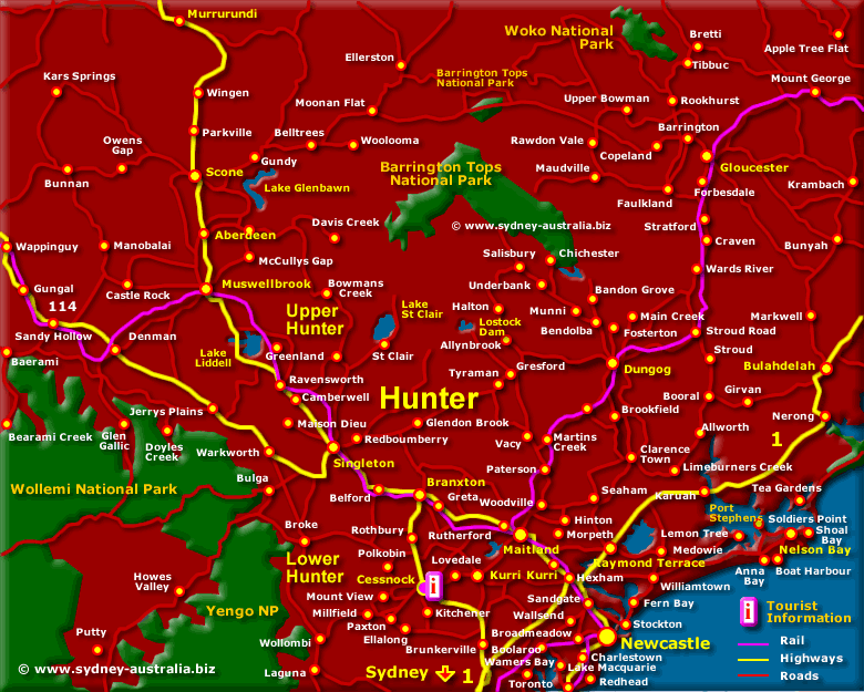
Map of the Hunter Valley wine growing region - Hunter wines are amongst the best Australia produces. See more about the Hunter Valley Wine Region.
The map shows Upper and Lower Hunter as well as Newcastle, Port Stephens, Cessnock, Maitland, Branxton, Singleton, Muswellbrook, Scone, Wollemi National Park and the Barrington Tops National Park.
Hunter Valley Tours, Experiences and Things to Do
See about Hunter Valley Wine Tours - Newcastle Tourist Information - Hunter Valley Weather.
Places to Visit
Places to Visit
This historic area is the oldest wine growing region in Australia.
Attractions and Museums
NSW Museums: Museums in New South Wales.
NSW Attractions - NSW Art Galleries.
Getting There
To get to the Hunter, approximately 1.5 hours north drive from Sydney. Take the Pacific Highway over the Sydney Harbour Bridge to Highway 1 at Hornsby, then head towards Newcastle. Head into the Hunter region by exiting at the Cessnock Hunter Exit.
There are strict drink driving laws in NSW, so you may wish to consider one of the many Hunter wine tours available in the area, taking in the fine wines and the cuisine without the risk. See more about the Hunter Valley Winery Tours and Hunter tours from Sydney.
Other Wine Growing Regions
To see more great Australian wine growing regions Australian Wine Growing Regions.
Accommodation in the Hunter NSW
Main Photo: Map of the Hunter Valley
Search the Australia Tourist Guide |


