Maps of Queensland Australia
Queensland Coast
- Far North East Queensland Map
- Central Queensland Map
- South Queensland Map
- South East QLD Map
- Bundaberg Surrounds Map QLD
- Cairns Map Tropical North Queensland
- Capricorn Coast Map QLD
- Cooloola Coast Map QLD
- Fraser Coast Map QLD
- Gold Coast Map Queensland
- Mackay Surrounds Map QLD
- Rockhampton Qld Surrounds Map
- Sunshine Coast Map QLD
- Surfers Paradise Map Queensland
- Townsville Surrounds Map QLD
- Whitsunday Coast Map QLD
Brisbane
- Brisbane Map - Places To Go
- Brisbane Tourist Attractions by Name
- Brisbane Hotels Map
- Brisbane Hotels by Name
- Greater Brisbane Map, Queensland
Queensland Regions
- Barcaldine Surrounds Map QLD
- Blackall Surrounds Map QLD
- Blackwater Surrounds Map QLD
- Charters Towers, Hughenden Map QLD
- Clermont Qld Surrounds Map
- Emerald Surrounds Map QLD
- Gladstone Surrounds Map QLD
Australia Great Barrier Reef
- Australia Great Barrier Reef
- Fitzroy Island
- Great Keppel Island
- Heron Island
- Orpheus Island, Australia Great Barrier Reef
- Wilson Island
East and West
Maps of Australia
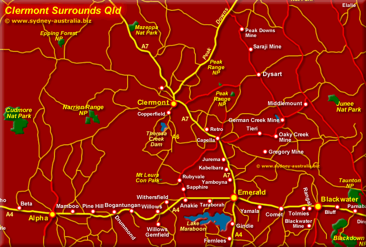
Clermont Qld Map - Surrounds
The route from Emerald to Claremont in Central Queensland, called the Gregory Developmental Road (A7) takes you north to Charters Towers and then to Townsville. You can also take the Peak Downs Highway to Mackay and the QLD Coast from here.
Clermont Qld Map - Surrounds
Clermont is a mining and agricultural town near the Peak Ranges. To the west is Narrien Range National Park and the Cudmore NP. To the east is the Peak Range NP and to the north, the Mazeppa NP.
Things to Do
Amongst the many things to do in Clermont and Surrounds include searching for Gold, visiting the old mining town, visiting the Clermont Museum and exploring the nearby Mackay Region with its stunning beaches, offshore island and green hinterlands Mackay Queensland.
Visiting Queensland
Australia Tourist Guide
About jobs, work and employment in Australia: Work in Australia - Jobs.
For Hotels and other accommodation, see Hotels in Australia.
To the South of Queensland, see more about New South Wales.
Hotels in Queensland
Queensland accommodation includes hotels, motels, luxury resorts, caravan parks, camping, bed and breakfasts and farm stays.
Main Photo: Click to see more about the Queensland Outback
Search the Australia Tourist Guide |


