Australia Tourist Guide -> Western Australia Tourist Guide -> South Coast -> South East Coast WA -> South East Western Australia - WA Tourist Information

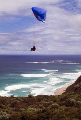
Photo: Paragliding on the Coast

Western Australia
Perth Places to Visit
- Western Australia
- Perth Australia WA
- Perth City Central CBD
- Perth Places to Visit
- Fremantle Perth
- Rottnest Island WA Perth
- WA National Parks
Adventure and Things to Do
- Perth Kids Activities
- Perth WA Aboriginal Arts, Culture
- Perth Tours, Cruises and Activities
- Perth Tourist Info
- Perth Weather
- Perth Hotels WA
- Perth CBD Map
Regions
- Best Places to Visit in Western Australia
- Kimberley Western Australia
- Broome Western Australia
- Broome Weather
- Central Coast W. Australia
- Monkey Mia - Shark Bay Midwest WA
- North West W. Australia
- Ningaloo Reef WA
- South East WA
- South West WA
- South Coast WA
- Albany WA
- WA Attractions
- WA Museums
Maps of WA
Australia Tourist Guide -> Western Australia Tourist Guide -> South Coast -> South East Coast WA -> South East Western Australia - WA Tourist Information
Mobile Version: Mobile


South East Western Australia - WA Tourist Information
Stretching from Ceduna in South Australia westward towards Norseman in WA, the Nullarbor Plain covers some 200,000 square kms.
Nullarbor Plain
On the map, the Nullarbor Plain may appear to be the sort of place you just want to get across as fast as you legally can. However, there are numerous places on the Nullarbor Plain worth taking the time to stop off and explore.
With the Gold Fields and vast deserts to the north and the Southern Ocean to the south, this red dust area has seen the rise and fall of many places dictated by gold finds. The area has just over 200mm of average rainfall a year.
The Eyre Highway, as this part of the Australia Highway 1 is called, has one stretch between Caiguna and Balladonia that travels in a straight line for 146.6 km. The highway is named after the leader of the European explorer party that first attempted and crossed the Nullarbor in 1841.
Eucla
Eucla, only 11kms from the South Australia / Western Australia border was originally established to serve as a telegraphic repeater station in 1877, manually operated. This particular place was chosen for the simple reason that supplies could be landed here. To the east is the longest cliff face in the world, formed over millenia by the forces of nature, especially the wind and storms of the Southern Ocean.
The remains of the old Telegraph Station at Eucla evoke images of a past time, visitors love to photograph it. There are actually other old abandoned buildings here, covered and uncovered by sand dunes as the winds move the dunes over time.
There are magnificent views of the cliffs stretching towards the horizon at the Eucla National Park.
Thylacoleo Caves
At the Thylacoleo Caves, numerous fossils of the mammals, birds and reptiles that lived here between 400,000-800,000 years ago have been found. 23 kangaroo species have been discovered so far in this cave system along with many other animals, having plunged 60 metres to their death accidently in the limestone sinkhole.
Over the many years massive waterfilled sinkholes and cave systems that have formed in the limestone rock over millenia. In fact, the Nullarbor Plain is formed over the largest single deposit of limestone in the world.
One of the most interesting creatures found at the Thylacoleo Caves is the Thylacoleo carnifex, an extinct marsupial lion.
Australian Megafauna
It was in this time period the ‘Megafauna’ of the Australian continent roamed. Some examples of this megafauna include wombats two metres high and a bird called the Demon Duck of Doom, with a weight of up to 250kg and a height of 2.5 metres. There were also, it is believed, seven metre long goannas, crocodiles that could apparently climb trees and huge flesh eating kangaroos.
Not the sort of thing you would want to meet in a dark alley somewhere.
Roadhouses
Many of the places along the Eyre Highway at this point are roadhouses. Set up to cater for the many travellers going east or west, they supply things like water, fuel, food and other supplies. Some have accommodation. Cocklebiddy is one of them, as is Mundrabilla, Madura and Caiguna.
Not far from Cocklebiddy, is one of the largest cave systems in the world, the Cocklebiddy Caves. At Madura, the Madura Pass Lookout has some magnificent views of the surrounding countryside.
Norseman
On the west extreme of the Nullarbor Plain is Norseman. This town stands on a goldfield and was named after the horse that first uncovered a gold nugget here. You can also try your hand at finding gold here, fossicking is allowed but you will need to obtain a license first, available from the Norseman Visitors Information Centre, located at 68 Roberts St, Phone +061 8 9039 1071.
Beacon Hill provides good views of the area
Accommodation
There are hotels, resorts, motels and other accommodation suitable for most budgets in the major centres. At the roadhouses, there may be a motel or hotel. Quaint bed and breakfasts, caravan parks, campsites as well as backpacker hostels are scattered on the main routes further west.
National Parks and Reserves
Reserves and National Parks in the SE: WA South East Map of National Parks and Reserves.
Near Perth and further afield, see reserves and national parks map for the South West: National Parks and Reserves Map South West WA.
Western Australia
Broome Western Australia
In the North East of the state: Broome WA.
Work, Jobs in Australia
Curious about trying about working on holiday in Australia? - Find out more at Work in Australia.
Western Australia Hotels and Accommodation
Australia accommodation and hotels - Accommodation Australia.
Search the Australia Tourist Guide