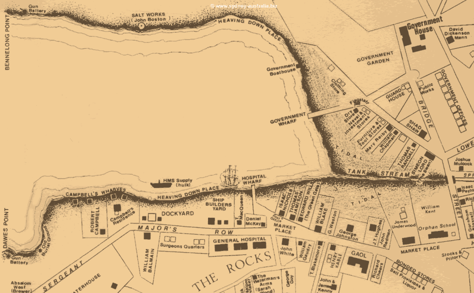
Photo: Map showing Sydney Cove in the Early 1800s.
Previous Sydney Cove Next Circular Quay
Sydney Suburbs to Visit
Central City (Downtown)
- Sydney CBD
- Camperdown NSW
- Camperdown Restaurants
- Darling Harbour
- Exploring the City: Sydney Tower
- Sydney Chinatown
- The Rocks
- Newtown Places to Eat
- Sydney Beach Suburbs
Sydney Harbour
- Sydney Harbour
- Harbour Beaches
- Sydney Cove
- Sydney Ferries
- Double Bay
- Elizabeth Bay
- Manly Ferry and Sydney Harbour
- Fairlight House
- North Head
- Places in Australian History
- Bradleys Head, Sydney Harbour
- Mosman
Inner City Suburbs
Sydney North Beach Suburbs
- Collaroy Beach
- North Curl Curl Beach
- Dee Why Beach
- Freshwater Beach
- Long Reef Beach
- Manly
- Mona Vale
- Manly Beach
- Manly Attractions: Sea Life Sanctuary
- Sydney Harbour Bridge
- Narrabeen Beach
- Newport
- Palm Beach
- Pittwater Sydney
- South Curl Curl Beach
- Warriewood Beach
- Whale Beach
Sydney East Beaches
- Bondi Beach
- North Bondi Beach
- Bronte Beach
- Collaroy
- Coogee
- Coogee Beach Map
- Cronulla Beach
- Cronulla Beaches
Outer Suburbs to Explore
Sydney Cove Map - Early 1800s
See location - Map of Attractions at Sydney Cove.
This map shows the beginnings of Sydney Australia as it was when still not much more than a village, a penal colony and the beginnings of the Colony of New South Wales. The windy streets shown here would soon be added to with wide boulevards and much more grand buildings.
Sydney Cove is the place where the the convicts and soldiers of the First Fleet in 1788 settled the birthplace of the country of Australia, this small cove has been an integral part of Sydney’s history ever since.
Bennelong Point: The Sydney Opera House
Bennelong Point is named after the Aboriginal that used to live there. It is now actually the site where the Sydney Opera House is located.
Dawes Point
On the other side of the cove, Dawes Point became the site where the Sydney Harbour Bridge would be built in the 1930s, during the Depression Years.
The Rocks
The Rocks, is where the convicts were first forced to camp. Eventually, most were moved out to the farming areas to work as labourers.
Now a restored historical district, you can see many of the building that survived such as Campbells (Wharves) Storehouses and the cobbled streets. Luckily the Stocks & Pilloriy are no longer there (On the lower far right of the map).
The Gaol and the Prison were moved to the other side of the town, as was the hospital, still only in planning stages when this map was created.
Circular Quay
Now a major terminus, the original circular part of the Quay was been filled and the Tank Stream, the original water supply for the First Fleet settlers has now been covered over. It is still there, however.
The hulk of the HMS Supply lies on its side in Sydney Cove on this map. This ship was the original supply ship for the First Fleet.
The Museum of Contemporary Art is now located just on the west side of Circular Quay, as is The Rocks.
The Cove Today
Sydney Information Centre
Sydney Information Centre - Offering visitors not only information, they have a good collection of artefacts and other items on display from earlier Sydney.
See Sydney Map of the City - Sydney Attractions.
Sydney Cove Photos
See also the World Youth Day Photos of the Pope’s Boat-A-Cade to the Cove.
Cove Places to Eat
Work, Jobs in Australia
Thought about a working holiday in Australia? Find out more Work in Australia. You may also be eligible to work while studying here Study in Australia.
Sydney Accommodation
Sydney and Australia accommodation - Australia Hotels.
Main Photo: Map showing Sydney Cove in the Early 1800s.
Search the Australia Tourist Guide |

