Australia Tourist Guide -> Victoria Tourist Guide -> Places to Visit -> Maps -> Touring the Victoria Coast

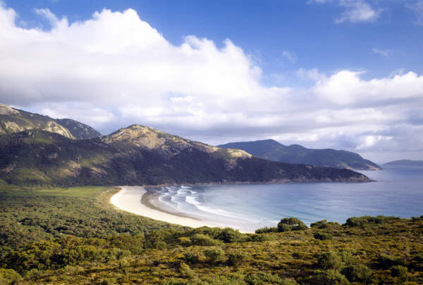
Photo: Wilsons Promontory Beach. Photographer Hamish Ta-me - Australia Tourism Copyright.

Victoria Australia
Places to Visit
- Victoria Places to Go, See and Visit
- Victoria Best Places
- Victoria and Melbourne Events
- Victoria Coast
- Victoria Wineries
- Victoria Attractions
- Museums in Victoria
- National Parks and Reserves
Regional
- Gippsland East Victoria
- Goldfields Victoria
- Grampians Victoria
- Great Ocean Road Great Ocean Road - Towns, Cities and Places
- Victoria High Country
- Macedon Victoria
- Mornington Victoria
- Murray Victoria
- Mildura Australia
- Phillip Island
- Yarra Valley
Melbourne Australia
- Melbourne Australia
- Melbourne Events
- Melbourne Restaurants
- Melbourne Australia Attractions
- Museums in Melbourne
- Landmarks
Places to Visit in Melbourne
- Melbourne Australia Best Places to Visit
- Places of Interest
- Inner City Melbourne CBD
- Surrounds and Suburbs
- Yarra River Melbourne
Visitors Information
- Melbourne Tourist Info
- Melbourne Tours
- Melbourne City Transport
- Weather for Today
- Melbourne Kids Activities
Maps showing Melbourne Attractions
- Melbourne Australia Map
- Melbourne Hotels Map
- Melbourne Hotel and Destination Travel Packages
- Melbourne Luxury Hotels
Maps of Victoria
- Victoria Tourist Maps
- Melbourne City Map
- Greater Melbourne Map
- Great Ocean Road Map Victoria
- Gippsland, High Country Victoria Map
- South Gippsland Map - East Coast of Australia
- Phillip Island Map Victoria
- Victoria and NSW Touring Map
National Parks
- National Parks
- Great Otway National Park Australia
- South Coast National Parks
- NSW and Victoria National Parks Map
- Croajingolong National Park
Australia Tourist Guide
Australia Tourist Guide -> Victoria Tourist Guide -> Places to Visit -> Maps -> Touring the Victoria Coast
Mobile Version: Mobile


Touring the Victoria Coast
Victoria has some of the most dramatic coastal scenery found in Australia. In the hinterlands, there are volcanic plains, wildflower heathlands and mountains covered with lush rainforests, much of it protected by National and State Parks and Reserves.
Wilsons Promontory National Park is known for its rugged beauty and wildlife, the Gippsland Lakes Region has its gourmet deli trail and historic townships. To the west of Melbourne, you can experience the Great Ocean Road, while close by is the Mornington Peninsula and Phillip Islands, each with their own attractions.
East of Melbourne Victoria
Mornington Peninsula
On Port Phillip Bay is the Mornington Peninsula. Long a favourite Melbourne escape, there are notable wineries to visit and choice in the type of beach you may wish to visit, whether a quiet swim at one of the Port Phillip Beaches or surfing the wild waves at Western Port.
Having been a popular getaway close to Melbourne for so long, the Mornington Peninsula has plenty of choice in both restaurants and accommodation, as well as 20 golf courses. See more about Mornington Peninsula,Victoria.
Melbourne To Phillip Island
Phillip Island has amongst its attractions the nightly penguin parade, the Grand Prix Circuit and the Koala Centre. Approximately 1.5 hours drive from the centre of Melbourne.
You can view the penguin parade in the Phillip Island Natural Park from the viewing platforms at Summerland Beach. Seal Rocks, home to thousands of fur seals can be seen at Nobby’s head. See more about Phillip Island Victoria.
Take the Princes Highway from Melbourne past Cranbourne to the South Gippsland Freeway, then on to the Bass Highway. This will take you to Phillip Island. See the Phillip Island Map Victoria.
Wilsons Promontory National Park
Two-hours drive from Melbourne via the South Gippsland Highway, Wilsons Promontory, referred to as ‘The Prom’ by the locals, occupies the south east tip of mainland Australia and is the furthest south point.
The granite mountains, once an island formed by volcanic activity long ago have been joined to the mainland by the actions of sea and wind, forming the sandbar of Yanakie Isthmus.
There are signs of early habitation of this beautiful region, Aboriginal archaeological sites such as Middens (shell heaps) found in and around the park date back thousands of years.
Springtime brings the park to life with wildflowers. There is plenty of wildlife, including wombats, kangaroos and emus to be seen in their habitat, as well as colourful native birdlife. The park is surrounded by the protected waters of the Wilsons Promontory Marine Park, which makes it a great place for diving and kayaking/canoeing.
The many walks and trails in the park offer something for everyone, you can hike the park for days or take a casual 10 minute stroll to one of the pristine white sand beaches.
The road from the mainland leads to Tidal River, site of a gorgeous beach and an information centre. There is accommodation available at the Tidal River, you can hire self contained cabins and group lodges or enjoy the campsite.
Prom Country Information Centre
For more information about Wilsons Promontory National Park, accommodation and the surrounding region, contact the Prom Country Information Centre. Phone 1800 63 0704.
Gippsland Coast
Travelling further northward on the east coast of Australia takes you through the Gippsland region, the coast here is largely protected by the Gippsland Lakes Coastal Park and the Lakes National Park.
The three main lakes and extensive waterways make this the largest inland network of water. You can hire boats here, or join a cruise at Lakes Entrance. See more about the Gippsland, Victoria
Gippsland Maps: South Gippsland Map - East Coast of Australia - Map of Gippsland Victoria.
Touring from Sydney NSW
Take the Princes Highway 1 to Gippsland Victoria to Sale. From there you can take the Victoria coastal route with the South Gippsland Highway. Alternatively, you can visit Canberra ACT, the nation’s capital first and then heading south east via Cooma.
West of Melbourne Victoria
The south west coast of Victoria is one of the great scenic touring drives of Australia. Taking you past secluded bays and surf beaches, steep cliffs and limestone formations, the scenery here is stunning.
Bellarine Peninsula
Just to the south west of Melbourne is the Bellarine Peninsula. Popular as a daytrip from Melbourne, there are both ocean and bay beaches here. The waterfront of Geelong, the main city here, has the entertainment and restaurant precinct overlooking Corio Bay.
There are wineries here you can visit, the green hinterlands and the coast has sleepy villages for you to discover.
Great Ocean Road
From Geelong to the border of South Australia, the Great Ocean Road is certainly one of the most scenic in this country. The National Parks include thick forests and heathlands.
The natural limestone formations of the Twelve Apostles are found along the route as well as many attractions make this region a must visit. See more about the Victoria Ocean Road - with Map.
Coast of Victoria Maps
See Victoria Map Australia.
Wines and Wine Regions
About the Victoria Wine Regions and the wineries that produce the great wines of:
Victoria Accommodation
Melbourne Luxury Hotels. You can also search for other Victoria hotels and accommodation, complete with traveller reviews, maps, rates, location information and events.
Search the Australia Tourist Guide
Photo: Touring the Great Ocean Road Victoria