Maps of Sydney Attractions
- Map of Inner Sydney Australia
- Sydney Map CBD
- Map of Sydney Center South
- Sydney CBD Map showing City Central
- Sydney Hotels Map
- Sydney Cove Map - Where Australia Began
Sydney Places to Visit
- Sydney Map and Australia Tourist Maps
- Map of Sydney - Australia Tourism Info
- Greater Sydney Street Map
- Map to the Sydney Opera House
- Map of Sydney Center South
- Map of Sydney CBD
- Map Sydney - CBD, Surrounds and Australia
- Map - Sydney in 1855 East City
- Sydney Map in 1855 West City
Beach Suburbs
- Map of Manly - Sydney
- Manly Beach Map
- Sutherland - South Sydney Map
- Sydney Northern Beaches Map
- Sydney East and South Beaches Map
Sydney Inner Suburbs
- Sydney CBD Map - Darling Harbour and City
- Darling Harbour Map - Sydney Tourist Attractions
- Map of the Rocks Sydney Australia
- Sydney City Map - Kings Cross to Central
Suburbs
- Sydney Harbour - Cruises, Attractions, Places to Visit
- Map of Greater Sydney Surrounds
- Parramatta Map
- Map of Penrith, Sydney NSW Attractions
- Sydney Beaches Map East and South
Sydney Trains
- Sydney North Trains Map
- Sydney City Centre trains CBD
- Sydney South Train Stations Map
- Sydney Inner City West Train Stations
- Sydney Transport System Wynyard Circular Quay Map
NSW Maps
- Map of NSW Australia
- NSW Regions Map, Australia Tourist Information
- West NSW Map
- East Coast NSW Map
- Hunter Valley Map, NSW
- Australia Map and Australian State Maps
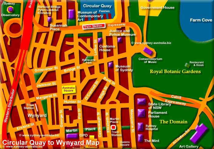
Sydney Transport system - Wynyard and Circular Quay Map
Map showing Circular Quay (above ground) and Wynyard (underground) train stations, two of the main transport hubs in Sydney Australia.
Circular Quay
Circular Quay has all the Sydney ferries that will take you to Manly beach, Parramatta, Darling Harbour, Balmain, Taronga Zoo and various Sydney northern suburbs. There are also taxis, while buses from here can take you to places like Bondi Beach and the eastern suburbs.
Wynyard
As well as taxis, there are buses that head to the northern suburbs from Wynyard, including the Sydney northern beaches and places like Manly Beach, Palm Beach and Newport.
Sydney trains heading north from the city stop at Wynyard for suburbs including North Sydney, Chatswood and Hornsby. Also trains heading west can be taken to Parramatta, Strathfield, Cabramatta and Penrith.
Bondi Beach by train: take the train from Town Hall to Bondi Junction. From there, there are frequent buses that take you to Bondi or other beaches along this part of the Sydney coast.
Sydney Airport Trains
City trains are an easy way to get to and from Sydney Airport. See more about Sydney Airport.
Museums in Sydney and New South Wales
NSW and Sydney Museums: NSW Museums.
Sydney Australia Train Station Maps
Sydney Australia Hotels
Main Photo: Sydney Transport Hubs, Wynyard and Circular Quay - Click to Zoom Out
Search the Australia Tourist Guide |


