Maps of Sydney Attractions
- Map of Inner Sydney Australia
- Sydney Map CBD
- Map of Sydney Center South
- Sydney CBD Map showing City Central
- Sydney Hotels Map
- Sydney Cove Map - Where Australia Began
Sydney Places to Visit
- Sydney Map and Australia Tourist Maps
- Map of Sydney - Australia Tourism Info
- Greater Sydney Street Map
- Map to the Sydney Opera House
- Map of Sydney Center South
- Map of Sydney CBD
- Map Sydney - CBD, Surrounds and Australia
- Map - Sydney in 1855 East City
- Sydney Map in 1855 West City
Beach Suburbs
- Map of Manly - Sydney
- Manly Beach Map
- Sutherland - South Sydney Map
- Sydney Northern Beaches Map
- Sydney East and South Beaches Map
Sydney Inner Suburbs
- Sydney CBD Map - Darling Harbour and City
- Darling Harbour Map - Sydney Tourist Attractions
- Map of the Rocks Sydney Australia
- Sydney City Map - Kings Cross to Central
Suburbs
- Sydney Harbour - Cruises, Attractions, Places to Visit
- Map of Greater Sydney Surrounds
- Parramatta Map
- Map of Penrith, Sydney NSW Attractions
- Sydney Beaches Map East and South
Sydney Trains
- Sydney North Trains Map
- Sydney City Centre trains CBD
- Sydney South Train Stations Map
- Sydney Inner City West Train Stations
- Sydney Transport System Wynyard Circular Quay Map
NSW Maps
- Map of NSW Australia
- NSW Regions Map, Australia Tourist Information
- West NSW Map
- East Coast NSW Map
- Hunter Valley Map, NSW
- Australia Map and Australian State Maps
Sydney City Map - Kings Cross to Central
See the Kings Cross Hotel Map Map Hotels City - Kings Cross.
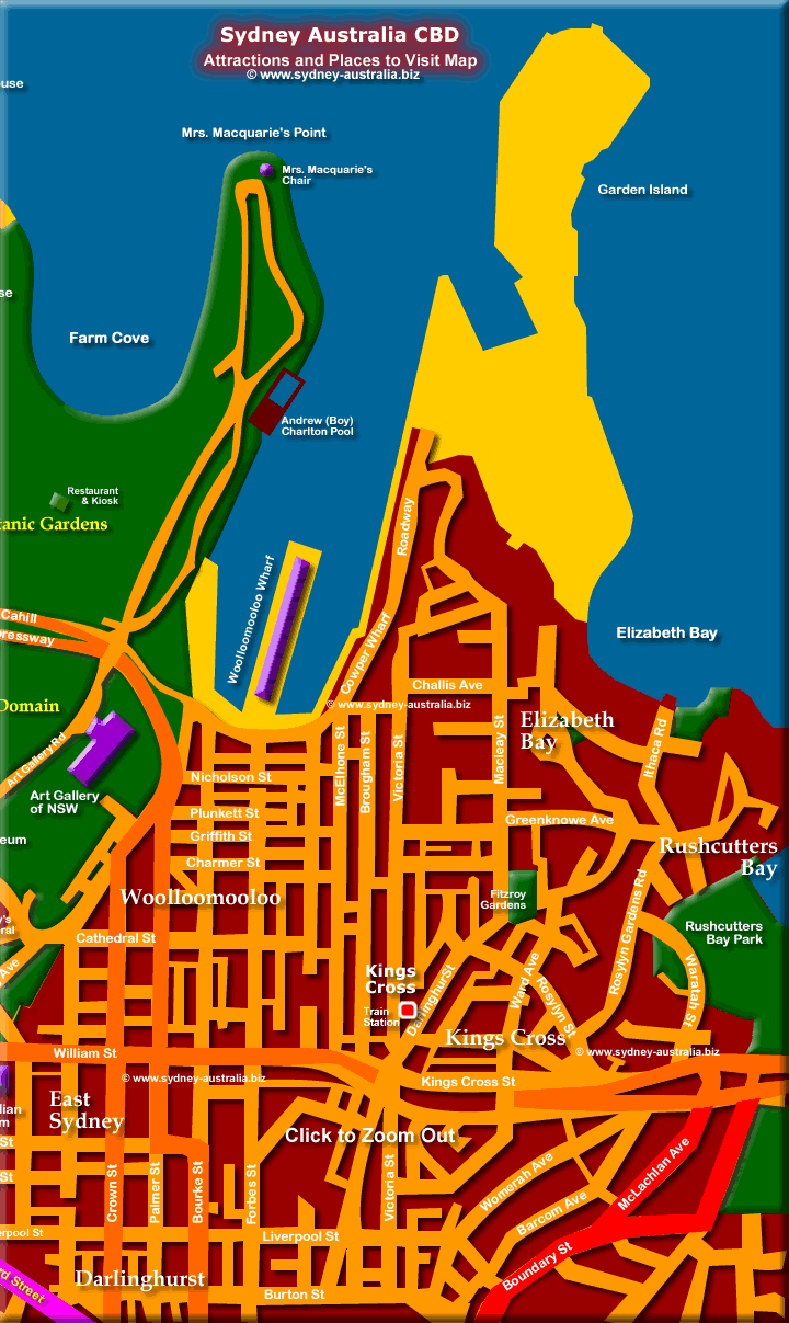
Map of Kings Cross and Darlinghurst. Shows Kings Cross, Darlinghurst, East Sydney, Elizabeth Bay, Fitzroy Gardens, William St, Kings Cross St, Garden Island and Woolloomooloo.
Mrs Macquaries Chair
Mrs Macquaries Chair at the top of the map is an excellent place for great views of the Harbour, with the Opera House framed by Sydney Harbour Bridge. The Royal Botanic Gardens is a short walk away, and leads west along the harbour to the Sydney Opera House. Sydney Opera House Map.
Next Picture: Sydney CBD Map - Darling Harbour and City - Sydney CBD Map - Darling Harbour and City.
Previous Picture: East Sydney CBD - East Sydney CBD.
Kings Cross and Darlinghurst
Kings Cross and Darlinghurst has numerous restaurants to try, while the Cross shows its alternative side at night. Known as the red light district of Sydney, the place booms with entertainment, nightclubs and pubs. See more about Kings Cross Sydney - Restaurants, Entertainment and Nightlife.
Woolloomooloo Wharf
Nearby Woolloomooloo, yes, thats right, 3 Ls and 8 Os, has a growing collection of restaurants, pubs and clubs. Also called the ’Finger Wharf,’ it was built and still is the longest wood covered wharf in the world.
Woolloomooloo Wharf, on Sydney harbour, between Garden Island and the Royal Botanic Gardens, has some choice restaurants onsite to try with ambient harbour views.
Hunter Valley NSW
To see Information about Sydney Wine and Winery Tours Sydney Wine Tasting Tours Hunter Valley.
Australia Tourist Guide
Thinking about a working holiday in Australia? See information about how to get jobs and Work in Australia.
Sydney Museums
Museums in Sydney: Museums in New South Wales.
Sydney Places to Stay
Accommodation includes hotels, motels, luxury resorts, caravan parks, camping, bed and breakfasts, backpackers and youth hostels.
Main Photo: Map of Kings Cross and Darlinghurst - Click to Zoom Out © www.sydney-australia.biz
Search the Australia Tourist Guide |


