WA Maps Western Australia
- Western Australia Map
- Perth CBD Map
- East Perth CBD Map
- West Perth CBD Map
- Greater Perth Surrounds Map WA
National Parks
- Ningaloo-Shark Bay
- WA National Parks and Reserves Map
- North East WA National Parks and Reserves Map
- North West WA National Parks and Reserves Map
- National Parks and Reserves Map South West WA
- National Parks and Reserves Map South West WA
Regional Maps
- North Western Australia Map
- North Coast WA Map
- North Central WA Map
- North East WA Map
- Central West WA Map
- Central Western Australia Map
- East Central WA Map
- South West Western Australia Map
- South Central WA Map
- South East WA Map
WA State Maps
- SE Map of Western Australia WA
- SW WA Map
- NW Western Australia Map
- NE Western Australia Map
- State WA Map South West
- State WA South East Map
- State WA North West Map
- State WA North East Map Australia
Maps of Australia
Northern Territory
South Australia
Tasmania
Victoria
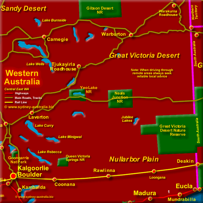
Central East WA Map
The population in this region is sparse, the land flat. The conditions are extremely dry with little fresh water to be found, Highway 1, or the Eyre Highway as it is called in this section, will take you to South Australia.
Nullarbor Plain and the Goldfields
At the Kalgoorlie-Boulder Visitors Centre there is gold jewellery and nuggets mined in the region on display, while exhibitions tell of the gold rush days and the geology of the surrounding area.
The Nullarbor Plain covers the south east of Western Australia. The name was derived from the Latin words, Nulla and Arbor, meaning no trees.
There are vast distances that separate most of the towns in this region. Always seek reliable local advice before travelling in these areas, take adequate supplies of petrol, food and water. Also, permits are needed before entering Aboriginal Lands.
Next Picture: Central West Western Australia Map - Central West Western Australia Map.
Previous Picture: South East WA Map - South East WA Map.
Central Australia
- Rudall River National Park
- Gibson Desert Nature Reserve
- Bililuna
- Balgo
- Giles Meteorological Station
- Warakurna
- Surveyors General Corner
- Telfer
- Lake Mackay
- Lake Dissapointment
Western Australia Attractions
Mid North W. Australia
- Marble Bar
- Nullagine
- Auski Roadhouse
- Roy Hill
- Newman
- Capricorn Roadhouse
- Collier Range National Park
- Rudall River NP
- Edgar Ranges
- Lake Dissapointment
- Lake Waukarlearly
- Gibson Desert National Reserve
- Great Sandy Desert
- Little Sandy Desert
- Lake Auld
- Port Hedland
- Great Sandy Desert
- Barrow Island
- Nanutarra Roadhouse
- Newman
- Gibson Desert
West Central WA
- Carnarvon
- Barrier Island
- Gibson Desert
- Geraldton
- Great Victoria Desert
- Mount Magnet
Western Australia Hotels
Main Photo: Central East Western Australia Map - Click to Zoom Out
Search the Australia Tourist Guide |


