WA Maps Western Australia
- Western Australia Map
- Perth CBD Map
- East Perth CBD Map
- West Perth CBD Map
- Greater Perth Surrounds Map WA
National Parks
- Ningaloo-Shark Bay
- WA National Parks and Reserves Map
- North East WA National Parks and Reserves Map
- North West WA National Parks and Reserves Map
- National Parks and Reserves Map South West WA
- National Parks and Reserves Map South West WA
Regional Maps
- North Western Australia Map
- North Coast WA Map
- North Central WA Map
- North East WA Map
- Central West WA Map
- Central Western Australia Map
- East Central WA Map
- South West Western Australia Map
- South Central WA Map
- South East WA Map
WA State Maps
- SE Map of Western Australia WA
- SW WA Map
- NW Western Australia Map
- NE Western Australia Map
- State WA Map South West
- State WA South East Map
- State WA North West Map
- State WA North East Map Australia
Maps of Australia
Northern Territory
South Australia
Tasmania
Victoria
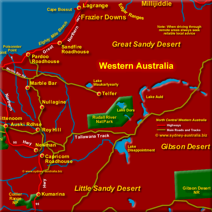
North Central WA Map
The Port Hedland to Broome route on Highway 1 is some 661 kms long. Along the way, between the Pardoo Roadhouse and Lagrange, there is the Eighty Mile Beach.
If your travelling north along Highway 1, note that the Pardoo Roadhouse is the last fuel station till you reach Sandfire.
There are beach camping areas and caravan parks along the way, although they may up to 23 km west of the highway.
See more about Kimberley Western Australia.
Next Picture: North East WA Map - North East WA Map.
Previous Picture: South West Western Australia Map - South West Western Australia Map.
Mid North W. Australia
- Marble Bar
- Nullagine
- Auski Roadhouse
- Roy Hill
- Newman
- Capricorn Roadhouse
- Collier Range National Park
- Rudall River NP
- Edgar Ranges
- Lake Dissapointment
- Lake Waukarlearly
- Gibson Desert National Reserve
- Great Sandy Desert
- Little Sandy Desert
- Lake Auld
- Port Hedland
- Great Sandy Desert
- Barrow Island
- Nanutarra Roadhouse
- Newman
- Gibson Desert
Central Western Australia
- Carnarvon
- Barrier Island
- Gibson Desert
- Geraldton
- Great Victoria Desert
- Mount Magnet
WA Far North Places to Visit
- Broome
- Derby
- Drysdale River National Park
- Fitzroy Crossing
- Purnululu (Bungle Bungle) National Park
- Kununurra
- Kimberley
- Wyndham
- Halls Creek
- Geiki Gorge National Park
- Drysdale River NP
- Devonian Reef NP
Accommodation Western Australia
Main Photo: Map of Central Western Australia, North - Click to Zoom Out
Search the Australia Tourist Guide |


