WA Maps Western Australia
- Western Australia Map
- Perth CBD Map
- East Perth CBD Map
- West Perth CBD Map
- Greater Perth Surrounds Map WA
National Parks
- Ningaloo-Shark Bay
- WA National Parks and Reserves Map
- North East WA National Parks and Reserves Map
- North West WA National Parks and Reserves Map
- National Parks and Reserves Map South West WA
- National Parks and Reserves Map South West WA
Regional Maps
- North Western Australia Map
- North Coast WA Map
- North Central WA Map
- North East WA Map
- Central West WA Map
- Central Western Australia Map
- East Central WA Map
- South West Western Australia Map
- South Central WA Map
- South East WA Map
WA State Maps
- SE Map of Western Australia WA
- SW WA Map
- NW Western Australia Map
- NE Western Australia Map
- State WA Map South West
- State WA South East Map
- State WA North West Map
- State WA North East Map Australia
Maps of Australia
Northern Territory
South Australia
Tasmania
Victoria
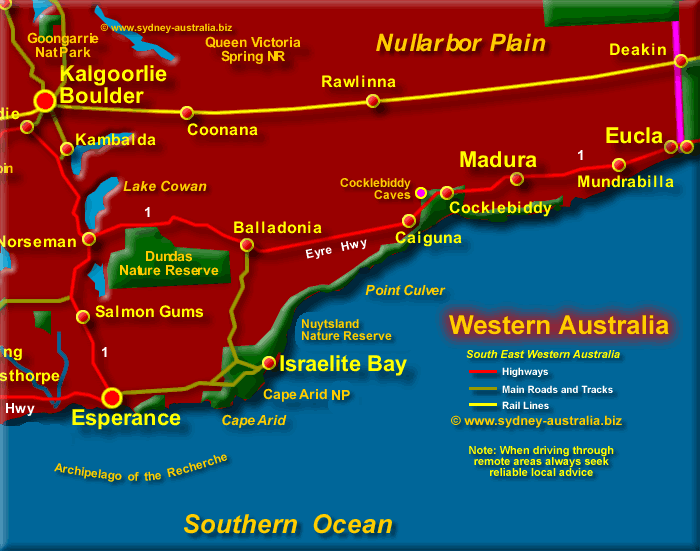
South East WA Map
South of Highway One, or Eyre Highway as this section is called, there is the Nuytsland Nature Reserve, a haven for birdlife. There are well over 200 hundred different species to be found here.
The Cocklebiddy Limestone Caves are sinkholes in the natural limestone, filled with water from underground river systems.
There are vast distances that separate many of the towns and places in this region. Always seek reliable local advice before travelling in these areas, take adequate supplies of petrol, food and water. Also, permits are needed before entering Aboriginal Lands.
More about this region South East Western Australia - WA Tourist Information.
Next Picture: South WA Map - South WA Map.
Previous Picture: East Central WA Map - East Central WA Map.
South East Western Australia
- Nuytsland Nature Reserve
- Dundas Nature Reserve
- Eucla
- Madura
- Mundrabilla
- Cocklebiddy
- Caiguna
- Balladonia
- Israelite Bay
- Nullarbor Plain
East Central Australia
- Neils Junction National Reserve
- Yeo Lake National Reserve
- Great Victoria Desert
- Laverton
- Lake Wells
- Lake Curry
- Lake Rebecca
- Queen Victoria Springs NR
Central Western Australia
- Carnarvon
- Barrier Island
- Gibson Desert
- Geraldton
- Great Victoria Desert
- Mount Magnet
WA Hotels and Accommodation
Main Photo: Map of South East Western Australia - Click to Zoom Out
Search the Australia Tourist Guide |


