Australia Tourist Guide -> New South Wales Tourist Guide -> Riverina NSW for Visitors

New South Wales NSW
New South Wales
Sydney Surrounds
- Blue Mountains
- Central Coast NSW
- Southern Highlands
- Bowral Restaurants NSW
- Hawkesbury Valley Region
- Hunter Valley
- Illawarra NSW
- Macarthur NSW
Central NSW
- Central NSW
- Central Tablelands
- Centre of Central NSW
- North Central NSW
- South Central NSW
- Riverina Region
- NSW Outback
North Coast NSW
Capital Country
Southern Highlands
Snowy Mountains
South Coast
- South Coast NSW
- Islands on the South Coast NSW
- NSW South Coast Tourist Information
- South Coast Places
- Eurobodalla
- Sapphire Coast
- Sapphire Coast Places to Visit
- Shoalhaven, South Coast
- Best Museums in the Surrounds
Popular Attractions
NSW Photos
- Mitchell Library
- Places to Visit
- St Andrews Cathedral
- Barranjoey Lighthouse
- Paddington Markets
- Queen Victoria Building
NSW National Parks
Australian Capital Territory
Greater Sydney Region
Sydney Museums
Australia Tourist Guide -> New South Wales Tourist Guide -> Riverina NSW for Visitors
Mobile Version: Mobile


Riverina NSW for Visitors
See Cootamundra on the map of west New South Wales NSW Maps or the Weather Far West NSW Weather.
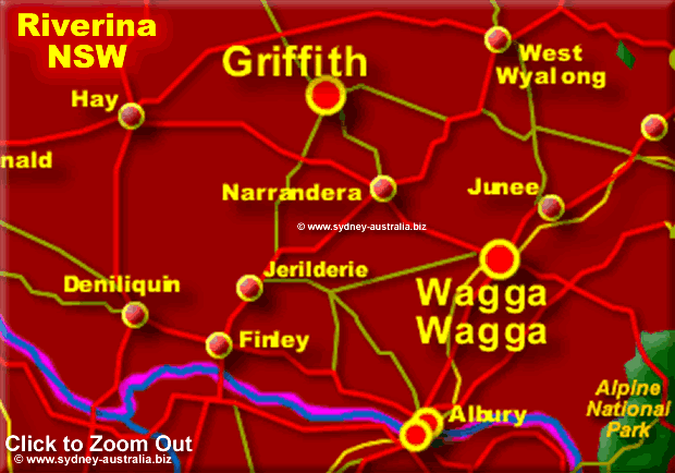
The fertile region of the Riverina in NSW has plenty to offer visitors wanting to explore inner Australia. Reaching from the Outback to the west part of the Great Australian Divide, there is history, national parks, heritage and culture to explore.
The region, fed by the Edward, Murrumbidgee and Lachlan Rivers is considered to be the food bowl of Australia, endowed with farms and wineries that will tantalise and delight visitors with the freshest of produce, gourmet foods and excellent wines. Restaurants and eateries, serving foods that feature diverse authentic cuisines from Europe to Asia using local ingredients, is a result of the many immigrants and their families that have made their home here over the years.
Places to Visit
Exploring the many places to visit here includes scenic drives.
Albury-Wodonga
On the border of NSW with Victoria, are the twin towns of Albury and Wodonga, divided by the Murray River. Paddlesteamers once plied this river in the second half of the 19th Century, bringing settlers, prospectors and goods upriver, returning with beef, wool and farm produce:
Albury-Wodonga
Balranald
The historic town of Balranald is the gateway to the Mungo National Park and the Yanga National Park:
Balranald and Surrounds, NSW
Cootamundra
Cootamundra, derived from an aboriginal word meaning turtle, swamp or low lying land. Rich farmlands surround, with cereal grains, beef and wool raised here since the late 1830’s. This charming town is also the birthplace of Sir Donald Bradman:
Cootamundra and Surrounds, Riverina
Corowa
The towns of Corowa, Howlong and Yarrawonga, set along the Murray River near the border of Victoria has watersports, gourmet foods, wines and nature to enjoy:
Corowa and Surrounds, NSW
Deniliquin
Located on the Edward River, there is plenty of heritage, wildlife and nature to explore:
Deniliquin and Surrounds, Riverina
Griffith
Griffith is the regional centre of the Murrumbidgee Irrigation Area and today is a thriving city.
Place to visit: Pioneer Park Museum tells the pre-history and history and growth of the Murrumbidgee Irrigation Area and Griffith with an interesting bush furnishings and equipment display.
Cocoparra National Park is some 25kms away, has lots of wildlife and is one of the rare but beautiful forest remnants of the Riverena area.
Griffith
Gundagai
Gundagai, made famous in Australian literature and home to the ‘Dog on a Tucker Box’. The longest wooden bridge in the southern hemisphere straddles the Murrumbidgee river here and since the town is almost half way between Sydney and Melbourne it has become a popular stop off point for travellers.
Gundagai
Hay
The town of Hay in the Riverina region of NSW is on the Murrumbidgee River. With five museums, festivals and events, wineries to visit and country living, visitors will find plenty to do and see.
Hay
Leeton
The designer of Leeton was Walter Burley Griffin, and still retains its circular streets and roads:
Leeton and Surrounds, Riverina
Wagga Wagga
Wagga Wagga, a modern city with an Aboriginal name from the traditional owners of the land, the Widadjuri, means ’Many Crows’. A garden city, because of its many green gardens and parks, is a commercial centre for the many farms and wineries in the surrounding area.
The restaurants here feature foods produced in the nearby farms, along with the many regional wines available here. You will find a number of them on the main street, Fitzmaurice St. and in its side streets.
RAAF Wagga Heritage Centre
Cocoparra National Park
The Cocoparra Range, waterfalls and waterways are what mark this beautiful park. In the spring, wattles, wildflowers and orchids bloom.
Birdwatchers and nature lovers delight in the many bird species that live or migrate through here, including soaring peregrine falcons. Other species include speckled warblers, diamond firetails and on the ground, heathwren.
The Wiradjuri people walked this land, the name Cocoparra is their name for Kookaburra. Numerous sites where they lived and used are still here.
The Long Paddock
The Long Paddock, formed in 1840s. This route from afar as Queensland and the far west of New South Wales had and still does have and important role to play in the economy of both states:
The Long Paddock
Regions of NSW
NSW Central Regions
Further Reading
Search the Australia Tourist Guide